Community
 Farmington, MI - The Crossroads Where Dreams Come To Life.
Farmington is the crossroads community at the heart of south Oakland County - one of the wealthiest in the U.S. In Farmington you'll find a hometown quality of life. Farmington people still look you in the eye and say: "Hello. You're welcome here!"
Within a 10 mile radius of Farmington you will find:
- 152,631 households
- 33% of which have children living at home
- 383,840 people
Farmington itself has 10,423 people within the city limits, a median family income of $75,578 and a median housing value of $173,900. There is no better place to live in the Metro Detroit area than Farmington. And, no better value.
Come see for yourself.
Next door to Farmington you'll find:
| North | Farmington Hills and Bloomfield Hills, among the wealthiest communities in Oakland County. | |
|---|---|---|
| South | Livonia, rated among the best places in the U.S. to raise children. | |
| East | Southfield, where Oakland County goes to work. | |
| West | Novi, one of the fastest growing areas in all of Metro Detroit. |
Community Profile
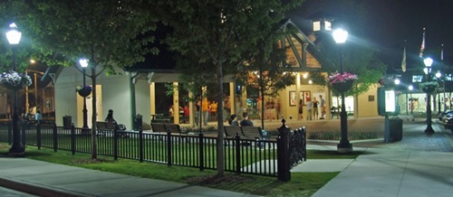
Riley Park at Night
Farmington was first settled in 1824 by Arthur Power, a Quaker from Farmington, New York. Soon after, in 1825, Dr. Ezekiel Webb established the first Post Office and became Farmington’s first postmaster and physician. The first school was established several years later in 1828. During the time of slavery, Farmington served as a station on the Underground Railroad.
In 1827, Farmington Township was established by the Legislative Council of the Michigan Territory. Farmington was officially incorporated as a village in 1867.
Town meetings were held in a variety of locations until the completion of the Town Hall (now the Masonic Hall) in 1876. Farmington became a home rule city in 1926.
Until the 1950’s, Farmington was considered a small village that primarily served the area’s farming community. During the post-war building boom, people began to move out from Detroit, transforming Farmington into a suburban area. During the late 1960’s, the City annexed 500 acres, which extended the western boundary of the City to Halsted Road.
Today, Farmington is the crossroads community at the heart of south Oakland County. Within a 10 mile radius of Farmington you will find: 383,840 people and 152,631 households, 33% of which have children living at home.
Farmington is identified by its pleasant neighborhoods, a graceful historic district and downtown shopping opportunities. The City strives to preserve and maximize these assets and provide for growth and redevelopment. To provide for growth and redevelopment, the City maintains a Master Plan for the downtown area and is participating in the National Main Street Center Program.
Community Description
 Location: The City of Farmington is located in southeastern Michigan in the southern part of Oakland County. The City is bordered on three sides by the City of Farmington Hills and on the south by the City of Livonia, which is in Wayne County.
The City of Farmington is located in metropolitan Detroit. Being a heavily urbanized region is taken into consideration for all planning, including community planning. As a result of community traditions and significant jointly-operated programs between Farmington and Farmington Hills, many area residents are unaware of geopolitical boundaries.
Transportation: Several major highways service the City. Grand River Avenue is a major east-west corridor through downtown Farmington. Farmington City Hall, which is centrally located in the City, is about five miles from Telegraph Road on the east and I-96 on the south. I-696 is about three miles north and I-275 about three miles west. The M-5 Freeway runs through the City and Eight Mile Road is on the southern border.
Because of the excellent highway system, most sections of the metropolitan area are readily available to Farmington’s residents. Since the opening of the Walter Reuther Freeway, I-696, even the far east side is less than an hour’s drive. A number of specialized facilities provide professional sports, popular music and various other events year round. Similarly, people from other communities utilize Farmington’s parks and patronize commercial recreational facilities in the City.
 Physical Resources: The Great Lakes are the dominant physical resource in the region and a number of inland lakes reinforce the popularity of water sports and water-based activities. Lake St. Clair, the Detroit River and Lake Erie are all within an hour’s drive and attract boaters, swimmers and fishermen. Farmington is about 25 miles from Lakes St. Clair and Erie, and most of the Detroit River is somewhat closer. The area to the west, from southwest to northwest, offers a variety of environments: hilly, wooded, agricultural, suburban, small towns, lakes and rivers.
The Upper Rouge River flows from Farmington Hills southward through the north and eastern portions of the City. The River valley is a distinct topographic feature that contributes to Farmington’s unique character. The northern segment of the River’s floodplain is occupied by parkland (Shiawassee Park). In addition, Farmington has several contiguous wooded areas, which combined, provide a continuous natural habitat that forms a natural wildlife link throughout the City.
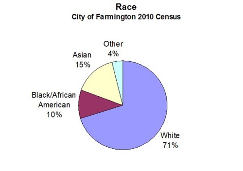
Census Information
Population: The following table compares several population characteristics gathered from 1990, 2000 and 2010 Census reports.
City of Farmington Census Data
| Population Characteristic | 2010 | 2000 | 1990 |
|---|---|---|---|
| Total Population | 10,372 | 10,423 | 10,132 |
| Total Households | 4,624 | 4,825 | 4,673 |
| Persons per Household | 2.22 | 2.13 | 2.17 |
| Total Families | 2,735 | 2,766 | 2,807 |
| Group Quarters | 122 | 136 | 121 |
Economic Profile
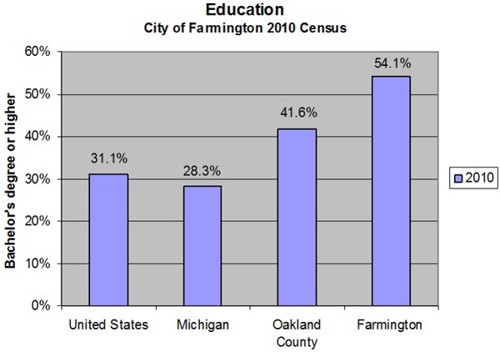
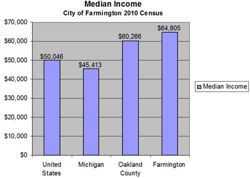
The Southeast Michigan Council of Governments prepares an annual edition of community profiles. The April 2011 profile for the City of Farmington, lists Farmington’s median household income (in 1999 dollars) as $56,442 and average housing cost (in 2000 dollars) as $173,900. This information is based on the 2010 census.
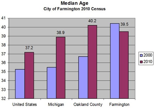
The 2010 census provides some comparisons with the large neighbors, Livonia to the south, and Farmington Hills to the north.
| Characteristic | Farmington | Farmington Hills | Livonia |
|---|---|---|---|
| Population | 10,372 | 79,740 | 96,942 |
| Density (per sq. mile) | 3,841 | 2,395 | 2,700 |
| Median Age | 39.5 | 42.1 | 44.5 |
Community Character
Central Business District
The central business district is a typical mid-western, small-town setting with a variety of uses, small lots, buildings built up-to the front lot line, and a quaint historic appearance. The structures within the downtown are a mixture of one and two story buildings. The downtown streetscape is characterized with wider sidewalks, pedestrian furniture, formal street trees, ornamental streetlights and on-street parking.
The central business district is centered at the intersection of Grand River Avenue and Farmington Road. In addition to the elements that define the urban form and character of the downtown, several key landmark buildings define Farmington as a distinct place. These include the Farmington Civic Movie Theater’s marquee sign, the Village Mall, the Masonic Temple and the plaza on the northwest corner of Grand River Avenue and Farmington Road.
The City has a Downtown Development Authority that has implemented a number of downtown improvements, including streetlights, street trees and pedestrian furniture. The DDA has developed a specific urban design plan for the downtown that recommends a number of improvements and modifications to the downtown shopping district. Elements of the Downtown Master Plan are discussed further in Chapter Five. However, since the Chapter Five discussion is only a summary of the Downtown Master Plan recommendations, any development or redevelopment within the Downtown Development Authority boundary should refer to the recommendations of this plan as well as those in the Downtown Master Plan.
Residential Neighborhoods
The residential neighborhoods within the City have varied characteristics. A positive attribute to the City is the mixture of housing type, size, age and price. This provides housing opportunities for a full range of family sizes and incomes, as well as resident age groups. This mixture includes smaller homes on small lots, large homes, townhouses, condominiums, apartments and senior housing.
Neighborhoods to the north and west of the central business district are the oldest homes in the City. Many of the structures in these neighborhoods are historic and are in good condition. It is necessary for this plan to focus on retaining this quality residential character.
In the eastern portion of the City are older neighborhoods that contain more modest homes on smaller lots. While these neighborhoods are largely in good condition, there are some areas that are beginning to show decline. Of particular concern are lots around the perimeter of the neighborhoods that abut commercial development. The older commercial lots along major roads such as Grand River Avenue and Orchard Lake Road tend to be shallow and provide limited opportunities for buffering between uses.
The neighborhood in the southern portion of the City along Farmington Road is an established neighborhood with housing stock that is in relatively good condition. Flanders Elementary School, located internally within this neighborhood, contributes to the quality neighborhood setting. Proper buffering of adjacent land uses will protect this neighborhood from any potential adverse impacts from industrial uses along Eight Mile Road and commercial uses along Farmington Road.
The more modern subdivisions in the western portion of the City are stable and in good condition. The quality of this area needs to be maintained and the neighborhood protected from more intense development around the M-5 and I-96 interchange.
Historic District
The City of Farmington’s Historic District, surrounding the central business district on the north and west sides, encompasses much of the original settlement dating back to the early 1800’s. Some of the significant structures within this district include: the first Post Office and residence of first town doctor, built in 1825; the oldest existing frame house in the City, built in 1824; the Masonic Temple and former Town Hall, built in 1876; the Quaker and Oakwood Cemeteries; and the residence of former Governor Fred Warner, presently the Farmington Historical Museum. A vast majority of the homes in the Historic District are mid-western examples of historic Michigan Farmhouse, Greek Revival, Gothic, Victorian and Bungalow architecture.
The Farmington Historic Commission maintains historic records and documents for the City. They review and comment on construction or renovation projects, and any demolition proposals within the Historic District. The Historic Commission should review and comment on all proposed demolition or relocation projects within the District, based on established guidelines for such consideration.
Historic properties in Farmington are considered to be those that are located with in the established Historic District (see map) and those listed on the National Register of Historic Places. Sites on the National Register must meet the National Criteria for Evaluation, which involves an examination of the age, integrity and significance of specific sites. These criteria are summarized below:
Age and Integrity - sites may qualify if the property is old enough to be considered historic (generally at least 50 years old) and whether it still presents the same appearance as it did in the past.
Significance - to be considered “significant,” sites must be associated with important historical events, activities, developments, people, architecture, landscape, engineering or potential archeological investigation.
Commercial Corridors
The major roadway corridors through the City are largely developed as commercial, intermixed with residential. Because these corridors are heavily traveled by both residents and visitors to the community, they are a key element in defining the character of the community.
Grand River Avenue: Traveling westward from Detroit along Grand River Avenue, one enters the City of Farmington just west of the intersection of Grand River Avenue and the M-5 Freeway. At this location, the eastern edge of the City, Grand River Avenue transitions from a boulevard to a five-lane road and M-5 traffic splits off and travels west as it approaches the I-696 Expressway. This portion of Grand River Avenue is characterized by older strip commercial uses on small lots. Many of the structures are built up-to the front lot line with a limited amount of open space or parking in front. The shallow lot sizes often cause front yard parking to be located within the Grand River Avenue right-of-way or in some cases, has required parking to be moved to the rear yard, which also contributes to conflicts with neighboring residential uses. The shallow lot sizes contribute to land use conflicts (noise, lights, blowing debris, views, etc.) with the residential neighborhoods immediately to the rear, and has lead to complete redevelopment, especially near Violet Street, where land annexation has allowed for more reasonable commercial lot sizes.
The intersection of Grand River Avenue with Orchard Lake Road is a principal node and gateway into the community. This intersection marks a change in the character of development lining Grand River Avenue from smaller more shallow lots to larger development sites. Buildings tend to be setback a short distance from the front lot line and parking is typically located in the side or rear yards. The larger lot sizes provide additional area to the rear of the buildings providing larger open spaces that act as a buffer from the abutting residential neighborhoods.
The intersection of Grand River Avenue and Power Road is located approximately half way between Orchard Lake Road and the downtown district. There is a smaller node of commercial uses at this intersection. While it contains a mixture of uses, including automotive service and repair, many of the uses fulfill a neighborhood service function as well. From this point westward, a mixture of smaller individual businesses intermixed with residential uses, gradually transitions into the central business district.
Entering the central business district, the setbacks from the roadway decline and the downtown streetscape, with formal street trees, ornamental streetlights and on-street parking, becomes more prevalent. In addition, Grand River Avenue narrows to four lanes through the downtown.
The central business district, centered at the intersection of Grand River Avenue and Farmington Road, is distinctly marked by the urban form and key landmark buildings. Continuing westward from the downtown, Grand River Avenue passes through the center of the Farmington Historic District. This area is dominated by historic residential structures that line Grand River Avenue to the western edge of the Historic District at Oakwood Cemetery. Despite the relatively high traffic volumes on Grand River Avenue, this area retains a quality residential charm.
Westward beyond the historic portion of the City, Grand River Avenue becomes a five-lane road lined with strip commercial development, intermixed with large apartment complexes. Traveling westward from Oakwood Cemetery, there is a distinct change in the streetscape character. The road becomes wider, buildings are set back further from the road with large front yard parking lots, and there are fewer mature street trees. These elements all contribute to an environment that is more accommodating to the automobile and less pedestrian friendly.
At the far western edge of the City, the M-5 Freeway intersects Grand River Avenue. This interchange is a major gateway to the community, providing connections with I-96, I-696 and I-275. The character of this intersection is largely dominated by automobiles. This intersection is not an environment that is hospitable to pedestrians, nor does it have a definable or unique character to delineate a gateway to the community.
Farmington Road: Farmington Road is the principal north-south road through the center of the City. The road enters the City at Eight Mile Road from Wayne County to the south. The intersection of Farmington Road and Eight Mile Road serves as a small commercial node that is shared between the cities of Farmington, Farmington Hills and Livonia. In addition to a small area of commercial development along Farmington Road, there is a large area of industrial uses along Eight Mile Road just east of Farmington Road. The cities of Farmington and Farmington Hills have a joint beautification committee that is working on streetscape improvements for Farmington Road between Eight and Nine Mile Roads
Farmington Road at the Nine Mile Road intersection, just south of the M-5 Freeway, is another major commercial node. This serves as the southern gateway to the central portion of the City. The M-5 Freeway overpass tends to be a physical barrier separating the Nine Mile area from the City’s downtown.
Beyond the M-5 Freeway overpass, Farmington Road passes through a mixture of residential and commercial land uses entering the downtown. The downtown is distinctly marked at the intersection with Grand River Avenue and the Masonic Temple. The landscape plaza serves as a landmark.
North of the downtown, Farmington Road passes through a historic residential neighborhood with the First Baptist Church at the road's terminus. Shiawassee Street serves as a key landmark terminating the view at the end of the road.
Passing through the Rouge River Valley, northbound Farmington Road traffic jogs eastward along Shiawassee Street. This street passes down a steep descent to the bridge over the Rouge River. Upon crossing over the river, the roadway enters into a large open public space located in the river valley. This is marked by the City park along the river and the surrounding hillsides occupied by the Farmington School District administration building and Our Lady of Sorrows Church and School.
At a location immediately east of the Rouge River Bridge, Shiawassee Street intersects with Farmington Road, which continues north. Farmington Road meanders northward up a steep ascent through a residential neighborhood to the City limit at Ten Mile Road. This area's residential character, located on rolling topography, continues into the neighboring City of Farmington Hills.
River Valley
The Upper Rouge River drains from Farmington Hills southward through the north and eastern portions of the City. The river valley is a distinct topographic feature that contributes to Farmington’s unique character. The northern segment of the river’s floodplain is occupied by City parkland. Much of the riverbank in the eastern portion of the City is under private ownership.
Shiawassee Park, located along the river, is a central node of civic functions with the school district administration and Our Lady of Sorrows overlooking the valley on the northern slopes. The river ties into the Grand River Avenue corridor near Power Road and flows through the eastern portion of the City. The river valley can be used as a natural greenway corridor to provide pedestrian linkages throughout the City.